summary
This tool was created to identify knickzones (relatively steep segment along rivers) using a DEM by user specified constraints. It also calculates the height and length of the kniczones. The toold is designed for Esri ArcGIS software, comprising two steps as below:
- Computation of relative steepness (Rd) raster for a given DEM.
Required:
- Spatial Analyst license
- TauDEM (5.1.1 for ArcGIS 10, 10.1, and 10.2)
- DEM as GeoTIFF format
- 'From', 'to', and 'by' values in scale for slope calculation
- Produces a knickzone shapefile.
Required:
- DEM as TIFF
- Rd (relative steepness) raster previously calculated
- Flow accumulation raster for stream network extraction
- A threshold value in Rd for knickzone extraction
download
help
- tool part I
computation of Rd raster by various scale slope calculation
- tool part II
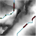
extraction of knickzones by Rd raster and knickzone form calculation
source code
- tool part I (txt)
- tool part II (txt)
references
- Hayakawa, Y.S., Oguchi, T., 2006: DEM-based identification of fluvial knickzones and its application to Japanese mountain rivers. Geomorphology 78, 90–106. doi:10.1016/j.geomorph.2006.01.018
- Hayakawa, Y.S., Oguchi, T., 2009: GIS analysis of fluvial knickzone distribution in Japanese mountain watersheds. Geomorphology 111, 27–37. doi:10.1016/j.geomorph.2007.11.016
- Zahra, T., Paudel, U., Hayakawa, Y.S., Oguchi, T. (2017.04) Knickzone Extraction Tool (KET) - A new ArcGIS toolset for automatic extraction of knickzones from a DEM based on multi-scale stream gradients. Open Geosciences, 9 (1), 73-88. doi:10.1515/geo-2017-0006